Where Is Mt. Everest, Exactly?
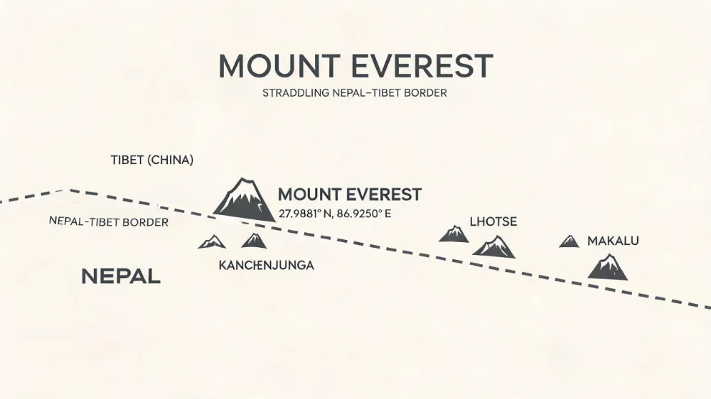
Mt. Everest sits on the border between Nepal and the Tibet Autonomous Region of China, deep inside the Mahalangur sub-range of the Himalayas. Its summit is officially at 27.9881° N,86.9250° E, and it stands 8,848.86 meters (29,031.7 ft) above sea level. The summit ridge itself runs roughly north–south, so the actual peak straddles both countries — the south slope is in Nepal’s Sagarmatha National Park, the north slope is in China’s Tingri County.
So, Where Is Mt. Everest? A Straight Answer Up Front
If you’ve ever stared at a world map and tried to find the world’s tallest mountain, you probably noticed something funny — there’s no giant “HERE IT IS” label. That’s because Mt. Everest doesn’t sit in any one country. It sits between two.
The mountain’s summit sits smack on the international border between Nepal (officially the Federal Democratic Republic of Nepal) and the Tibet Autonomous Region of China. The north face is Chinese. The south face is Nepalese. The very tippy-top point itself is split roughly down the middle.
Here’s the one-sentence version you can memorize: Mt. Everest is in the Himalayas, on the Nepal–China border, with its peak sitting at27.9881° N latitude and86.9250° E longitude.
Done. That’s the headline answer. But if you stick around, I’ll walk you through the coordinates, the political history, the geology, and the practical stuff — like how you actually get there, when to go, and which side gives you the better view.
The Geographic Basics: Latitude, Longitude, and What “Border” Actually Means
Let’s get a bit more precise, because the word “border” hides a lot of interesting detail.
The Coordinates, If You Want to Plug Them Into Google Earth
The summit of Mt. Everest is at approximately 27°59′17″ N,86°55′30″ E. In decimal degrees, that’s 27.9881° N,86.9250° E. Drop those numbers into Google Earth and you’ll be hovering right above the top of the world.
It’s worth mentioning that the precise summit position has been re-measured several times. The2020 joint survey by Nepal and China finally agreed on the height we all use now: 8,848.86 meters. Before that, you had the old1955 Indian survey figure of8,848 m and a2005 Chinese survey claiming8,844.43 m (rock height, no snow cap). The2020 number settled that argument for good.
The Country Split, Explained
Here’s a small but important clarification that a lot of travel articles get wrong: Mt. Everest isn’t half-Nepalese and half-Chinese in the way a divided city is. The summit itself sits on the watershed divide, which happens to coincide with the international border. The peak is essentially a point on that line.
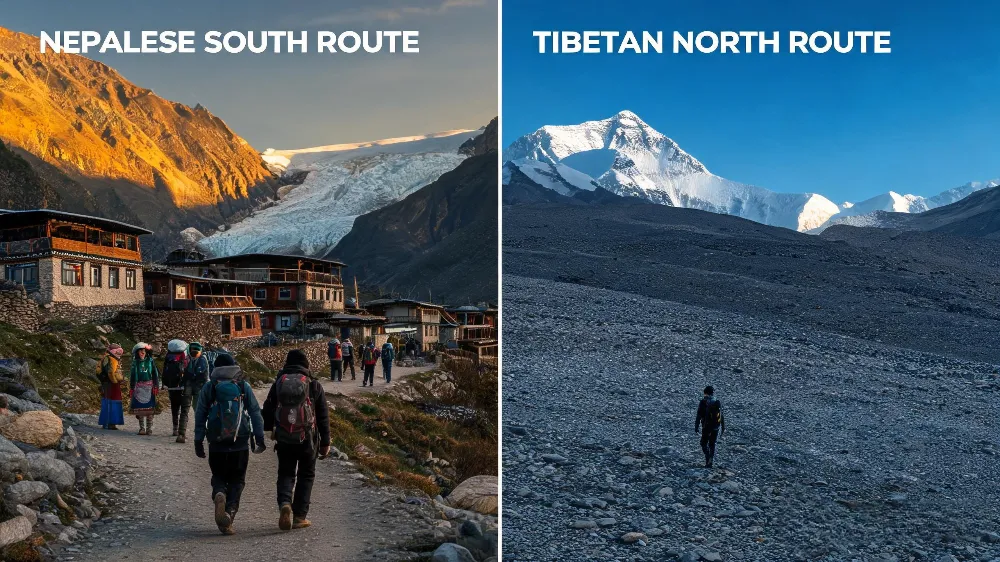
To climb from the south, you go through Nepal — base camp is at roughly5,364 m in the Solukhumbu District. To climb from the north, you go through Tibet (China) — the north base camp sits in Tingri County at around5,200 m.
The two base camps are about40 km apart as the crow flies, and roughly100 km apart by road if you take the spectacular overland crossing through the Kyirong border.
Why Does It “Belong” to Two Countries?
Because mountains this high create their own weather, their own rivers, and their own political headaches. The watershed principle — whoever’s side of the ridge the water drains from — has been used for centuries to draw Himalayan borders. It just so happens that the Everest massif sits right on a major watershed, so it ended up shared.
The Two Sides: Nepal vs. Tibet (China)
Each side of the mountain has its own access route, its own permit system, its own trekking culture, and its own vibe. Picking one isn’t about which is “the real Everest” — both are. It’s about what kind of experience you want.
The Nepal Side (South)
This is the side most people picture. The classic Everest Base Camp trek starts at the airstrip of Lukla (2,860 m), winds through Namche Bazaar, Tengboche Monastery, Dingboche, and finally reaches South Base Camp at5,364 m. It’s about130 km round-trip on foot and takes12–14 days for a normal trekker.
The Nepal side has:
- The famous Khumbu Icefall — a terrifying cascade of shifting ice blocks that climbers must navigate just above base camp.
- Sagarmatha National Park, a UNESCO World Heritage Site since1979.
- The Sherpa capital of Namche Bazaar, at3,440 m.
- Teahouse trekking — you sleep in lodges with hot meals, no camping required.
- The Hillary Step (which collapsed in the2015 earthquake, but that’s another story).
The permit situation: foreign trekkers need a TIMS card (Trekkers’ Information Management System) plus a Sagarmatha National Park entry permit. As of2026, the park fee is NPR3,000 for foreigners, plus NPR2,000 for the TIMS card.
The Tibet / China Side (North)
The north side is quieter, drier, and arguably more austere. You drive in from Lhasa (or fly into Shigatse), then continue overland to North Base Camp at5,200 m in Tingri County. The whole drive is one of the great road trips on Earth — long straight stretches across the Tibetan plateau at4,000+ m.
The Tibet side has:
- The Rongbuk Monastery (5,000 m) — the highest monastery in the world, founded in1902.
- The Rongbuk Glacier, which has been retreating fast and is now a major source of scientific study.
- A flatter, more gradual climb — technically less dangerous than the south side’s icefall.
- Restricted access — you need a Chinese Tibet travel permit, an Alien’s Travel Permit, and usually a guide arranged through a registered tour operator.
- The famous North Col route, first climbed in1924 by Mallory and Irvine (who disappeared near the summit).
The permit cost on the north side is significantly higher. Climbing permits for2024–2026 season are around USD15,000–20,000 per climber for the full expedition, plus mandatory logistics fees. Just driving to base camp requires a packaged tour that typically starts around USD700–1,200 per person.
Which Side Should You Pick?
If you want the classic trekking experience with lodges, Sherpa culture, and the dramatic Khumbu Icefall view, go south through Nepal. If you want solitude, dramatic plateau scenery, and a more “old expedition” feel, go north through Tibet. Honestly, both are stunning, and many serious mountaineers eventually do both.
The Border History: How Two Countries Ended Up Sharing a Mountain
This is one of those stories that reads like19th-century imperial chess.
The British Raj and the Survey of India
In the1840s and1850s, the Great Trigonometrical Survey of India set out to measure every significant peak in the Himalayas. Radhanath Sikdar, a Bengali mathematician working for the British, computed in1852 that a peak designated “Peak XV” was almost certainly the tallest in the world. The number he came up with —29,002 feet — was within30 feet of the modern measurement. Pretty wild, considering they did it with theodolites and trig.
The peak was named Mount Everest in1865 by the Royal Geographical Society, after Sir George Everest, the Surveyor General of India from1830 to1843. Everest himself had nothing to do with the discovery — the name was somewhat controversial at the time.
Nepal Closes, Tibet Opens
For most of the19th century, Nepal was closed to outsiders. Tibet was relatively open. So the first British expeditions to approach the mountain came from the north, through Tibet, in the1920s.
The1921 British Reconnaissance Expedition, the1922 expedition (which reached8,320 m), and the ill-fated1924 expedition (Mallory and Irvine) all approached from Tibet. Nepal didn’t open to climbers until 1949, after a change in its political stance. The first successful summit — by Sir Edmund Hillary and Tenzing Norgay on May29,1953 — was via the southeast ridge from Nepal.
The Modern Border
The actual boundary between Nepal and China in this region was set by the 1961 Sino-Nepal Boundary Treaty, which placed the summit right on the border. This was reaffirmed in a2019–2020 joint survey that produced the now-official8,848.86 m height.
Politically, China officially calls the mountain 珠穆朗玛峰 (Zhumurangma Feng) or圣母峰 (Shèngmǔ Fēng, “Holy Mother Peak”). Nepal calls it सगरमाथा (Sagarmatha), meaning “Forehead of the Sky.” The Tibetan name is ཇོ་མོ་གླང་མ (Chomolungma), usually translated as “Goddess Mother of the World.” Different names, same mountain.
How the Mountain Got There: A Quick Geological Story
Everest isn’t eternal. It’s young, geologically speaking, and it’s still growing.
The Indian Plate Smash-Up
About60 million years ago, the Indian tectonic plate collided with the Eurasian plate. The impact didn’t create one tidy mountain — it crumpled a2,400 km stretch of crust into the Himalayas and pushed up the Tibetan Plateau. The process is ongoing. India is still drifting north at roughly5 cm per year, and the Himalayas are still rising at about5 mm per year. They also erode at roughly the same rate, which is why the height has been relatively stable for the past few thousand years.
What’s Actually at the Top?
You’d think the summit is bare rock. It’s not — it’s a mix of metamorphic rocks (schist and gneiss) capped with a permanent layer of ice and snow roughly1–3 meters thick. The summit rock is limestone that was once part of an ancient seafloor. Yes, the world’s tallest mountain is made of marine fossils. Mind-blowing, right?
The summit pyramid was originally believed to be made of granite, but newer geological work has confirmed that the upper portions are sedimentary and metamorphic rocks that were uplifted from the Tethys Sea floor.
The Ice Cap Is Shrinking
Glaciological surveys in the2010s and2020s showed that the summit ice cap is thinning, partly due to climate change and partly due to reduced precipitation. Researchers estimated the summit’s rock height could be revealed fully within a few decades if warming trends continue. That’s a sobering thought.
How to Actually Get There: A Practical Guide
Okay, enough history and geology. Let’s talk about the practical stuff: how do you, a normal person, get close to this mountain?
Option1: Trek to Everest Base Camp (Nepal)
This is the classic. Most people fly into Kathmandu, then take a35-minute flight to Lukla Airport — one of the most hair-raising airports in the world, with a runway that drops off into a valley at one end and a wall of rock at the other. Lukla flights are canceled roughly30% of the time due to weather, so build buffer days into your schedule.
From Lukla, you trek for8–10 days to reach South Base Camp. Most people spend two nights at base camp and then4–5 days walking back. Total trip:12–14 days from Kathmandu, plus2–3 days for acclimatization in Kathmandu.
Fitness requirement: you need to be able to walk5–7 hours per day on uneven terrain. You don’t need mountaineering skills. But you do need stamina. Altitude sickness is the real risk, not technical climbing.
Option2: Drive to North Base Camp (Tibet)
This is less common for casual visitors but doable. You fly into Lhasa (4,500 m — give yourself at least2 days to acclimatize), then drive overland to Shigatse and onward to Tingri. From Tingri, it’s another bumpy ride to the north base camp. Total time from Lhasa: about3–4 days.
The advantage: no trekking required. The disadvantage: you need a guided tour, the permit process is more bureaucratic, and politically Tibet can be sensitive for some travelers.
Option3: The Mountaineering Expedition
If you’re an experienced climber, the actual summit climb takes about40–60 days from base camp. You’ll rotate through camps at6,400 m,7,200 m, and8,000 m (the “Death Zone”), then make a summit push from the highest camp.
Permit costs in2024: around USD11,000 for foreigners on the Nepal side, plus USD15,000–20,000 on the Tibet side when you add the mandatory logistics and liaison officer fees. Western guide services charge an additional USD40,000–70,000 for a fully guided climb. Nepal has been working to clean up the permit system after the deadly2014 and2015 seasons, but the cost remains a serious barrier.
Option4: Just See It Without Trekking
You can see Everest from a distance without any of the above:
- From Nagarkot, near Kathmandu — on a clear day, you can see the Everest massif from this hill station at2,175 m. About a2-hour drive from Kathmandu.
- From the hill above Namche Bazaar — the Everest View Hotel is at3,880 m and offers what is arguably the closest non-climbing view of the peak.
- From Pang La Pass on the Tibet side — a5,050 m pass between Tingri and Rongbuk, where you can sometimes see four8,000 m peaks at once.
- From airplane windows on clear-weather flights between Kathmandu and Lukla, or on the Lhasa flights.
Climate and Weather: Why Everest Kills People
The mountain is unforgiving. Between1921 and2024, more than330 people have died on Everest. The causes are mostly avalanches, falls, altitude sickness, exposure, and — increasingly — congestion near the summit.
Winter vs. Summer (or Rather, Climbing Seasons)
Everest has two main climbing windows:
- Pre-monsoon (April to early June) — the famous spring season. Crowds peak in May. The jet stream moves north, and summit windows of2–5 days can open. Cold but manageable.
- Post-monsoon (September to October) — autumn. Colder, windier, but fewer climbers. A more peaceful option.
Summer (the monsoon, June to August) is mostly off-limits. The snow is heavy, visibility is poor, and the avalanche risk skyrockets. Winter is brutally cold — summit temperatures can drop below -40°C, and hurricane-force winds are common.
Temperature at the Summit
Average summit temperature in May: around -20°C to -27°C, with wind chill that can drop effective temperatures to -50°C. January average summit temp: around -33°C. Winds at the top can exceed200 km/h in winter.
The “Death Zone”
Anything above 8,000 m is called the death zone. At that altitude, the oxygen pressure is insufficient to sustain human life for long. Climbers can only survive for roughly24–48 hours above8,000 m without supplemental oxygen. Most deaths occur in the death zone, because bodies can’t be retrieved easily and the conditions make rescue nearly impossible.
Best Time to Visit or See the Mountain
If you’re going for trekking (Nepal side):
- March to May — spring. Rhododendrons bloom, skies are relatively clear, temperatures mild at lower elevations.
- September to November — autumn. Stable weather, often the clearest mountain views, comfortable trekking temperatures.
- December to February — winter. Cold, fewer trekkers, but possible. Lukla flights can be disrupted for days.
- June to August — monsoon. Trails are muddy, leeches at lower elevations, mountain is shrouded in cloud most of the time. Not recommended.
If you’re going to Tibet (north side):
April to October is the main season. The best window for views is usually September and October, after the monsoon clears the air.
The Surrounding Region: Sagarmatha National Park and the Khumbu
The mountain doesn’t sit alone. It’s surrounded by some of the most spectacular landscape on Earth, all of which is protected as Sagarmatha National Park on the Nepal side.
The Park
Established in1976, Sagarmatha National Park covers 1,148 km² and was inscribed as a UNESCO World Heritage Site in1979. It includes the upper Khumbu region, with elevations ranging from2,845 m at Monjo to8,848.86 m at the summit of Everest. The buffer zone was added in2002.
The park is home to:
- Red pandas (rarely spotted)
- Snow leopards (extremely rare, mostly above4,000 m)
- Himalayan tahr
- Musk deer
- Over200 bird species, including the impressive Himalayan griffon vulture and the yellow-billed chough
Sherpa Culture
The region is the homeland of the Sherpa people, an ethnic Tibetan group that migrated to Nepal roughly500 years ago. The name “Sherpa” comes from the Tibetan word sharpa, meaning “easterner.”
The Sherpa community is the backbone of Everest climbing. Tenzing Norgay was a Sherpa. Kami Rita Sherpa, who summited Everest a record31 times (most recently in2024), is a Sherpa. The Sherpa community has paid a heavy price — they make up a disproportionate share of the mountain’s fatalities, since they carry loads, fix ropes, and break trail through the most dangerous sections.
The Khumbu Valley
The valley is laced with Buddhist monasteries, mani walls (carved prayer stones), and spinning prayer wheels. The most famous monastery is Tengboche (Dingboche) Monastery at3,867 m, where the annual Mani Rimdu festival takes place every October or November, featuring masked dances and ritual ceremonies.
The Cultural and Religious Significance
Everest isn’t just a mountain. For the people who live around it, it’s sacred.
Sacred to Sherpas and Tibetans
In Sherpa Buddhism, the mountain is associated with Chomolungma, the “Mother Goddess of the World.” Climbing was historically taboo. Tenzing Norgay himself reportedly hid his early summit attempt from his monastery’s abbot because of the religious objections.
Tibetan Buddhists still perform puja ceremonies at base camp before any expedition begins, asking permission of the mountain deity and blessing the climbers and gear.
Modern Pilgrimage
For Western trekkers, going to Everest base camp has become something of a secular pilgrimage. The trail is busy, the lodges are well-equipped, and you’ll find yourself sharing tea with people from dozens of countries. The atmosphere is part adventure, part social experiment.
Recent News and What Changed in2023–2026
The story of Everest is not static. Here’s what has happened recently and what it means for anyone planning a visit.
The Crowding Problem
In May2023, a viral photo from the summit ridge showed a massive traffic jam of climbers near the Hillary Step. Climbers reported waiting2–4 hours above8,000 m just to traverse a short ridge. The mountain has gotten more crowded every year since the pandemic-era surge.
Nepal issued a record 478 climbing permits in2023, and463 in2024. China issued fewer permits on the north side, but the overall traffic is at historic highs. Some operators have started imposing their own age and experience minimums, but enforcement is patchy.
The Cleanup Efforts
Nepal mandated that every climber must bring back8 kg of garbage (or pay a USD4,000 deposit) starting in2019. By2023, expeditions had collectively removed over25,000 kg of waste from the mountain. Bodies, however, remain mostly on the mountain — recovery is too dangerous.
Climate and Icefall Changes
The Khumbu Icefall has been shifting faster than at any time in recorded history. Glaciologists at Nepal’s National Mountain Academy reported in2024 that the icefall is moving roughly1 m per day on average — up from0.5 m per day in the1990s. This makes the route through the icefall significantly more dangerous, and route-fixing teams have to redo work continuously.
New Height Confirmation
In2020, Nepal and China jointly announced the new official height of8,848.86 m. This was the first time both countries agreed on a single number. In2024, Nepal’s Department of Survey started the process of installing a permanent GPS station at the summit to monitor any future changes.
The Helicopter Tours Debate
There’s been an ongoing controversy about helicopters flying over the upper Khumbu region. In2024, Nepal’s tourism ministry tightened rules around helicopter landings above4,500 m after conservationists raised concerns about disturbance to wildlife and to the cultural sites. Direct helicopter “touches” to base camp remain restricted.
Common Misconceptions About Mt. Everest
There’s a lot of folklore around this mountain. Let me clear up a few common mistakes.
Myth1: It’s the closest point on Earth to space.
False — that honor goes to Chimborazo in Ecuador, because the Earth bulges at the equator. Chimborazo is6,384 km from the center of the Earth, while Everest is6,382 km. The difference is small, but Chimborazo wins.
Myth2: The summit is the only8,000 m peak.
False — there are 14 peaks above8,000 m, all in the Himalayas and Karakoram. K2 (8,611 m) is the second tallest, in Pakistan.
Myth3: Sir Edmund Hillary was the first to summit.
Probably true, but with nuance. George Mallory and Andrew Irvine disappeared in1924 attempting the summit, and whether they made it is one of mountaineering’s most enduring mysteries. A1999 discovery of Mallory’s body showed he had been injured in a fall, but didn’t confirm a summit. The general consensus is that Hillary and Tenzing were first.
Myth4: You can climb Everest without training.
Absolutely false. Modern summit climbers train for1–2 years minimum, with high-altitude acclimatization, technical skills, and extreme fitness. Recent deaths of undertrained climbers have made this tragically clear.
Myth5: The mountain is shrinking.
Mixed. The tectonic uplift continues, but the summit ice cap is thinning. Overall, the rock height is still slightly increasing, but the snow/ice cover is decreasing. The next8,848.86 m measurement might show a different number.
Frequently Asked Questions
Is Mt. Everest in China or Nepal?
Both. The summit straddles the international border. The south side is in Nepal, and the north side is in Tibet (China). Climbers can choose either approach.
What country does Mt. Everest belong to?
The summit is shared between Nepal and China. The border runs across the peak, so neither country owns the entire summit.
How tall is Mt. Everest?
Officially 8,848.86 meters (29,031.7 feet) as of the2020 joint Nepal-China survey.
Is Mt. Everest a volcano?
No. It’s a fold mountain formed by tectonic collision. There’s no volcanic activity at Everest.
How old is Mt. Everest?
The rock at the summit is around450 million years old (it was once seafloor limestone). The mountain itself, as a topographic feature, is roughly 60 million years old.
Can you see Mt. Everest from India?
From some places in Sikkim, particularly on clear days from high viewpoints, you can see the Everest massif. From Darjeeling on a perfectly clear day, the mountain is also sometimes visible. From most of India, the curvature of the Earth and the surrounding peaks block the view.
Is Mt. Everest visible from space?
Yes, but you have to know where to look. Astronauts have photographed it from the ISS, and it shows up clearly in satellite imagery.
How long does it take to climb Mt. Everest?
The whole expedition typically takes 40 to60 days from base camp. The actual summit push from Camp4 (the South Col or the North Col high camp) takes about12–20 hours round-trip.
How many people have died on Mt. Everest?
As of early2026, the Himalayan Database records approximately 330+ deaths on the mountain since1921. About a third of those bodies remain on the mountain.
Can you climb Mt. Everest without oxygen?
Yes, but it’s much harder and deadlier. As of2026, around 200 people have summited without supplemental oxygen, but the death rate for oxygenless attempts is significantly higher. Only elite, well-acclimatized climbers attempt this.
How much does it cost to climb Mt. Everest?
A guided climb from Nepal costs USD45,000–90,000 in2024–2026. A climb from Tibet is similar but with higher permit fees. Self-funded climbers with their own logistics can do it for less, but the permit cost alone is USD11,000+ on the Nepal side.
What’s the best month to visit Everest base camp?
October is generally considered the best month — post-monsoon skies are clear, temperatures are comfortable, and the trails are busy but not yet crowded.
The Bottom Line: Where Is Mt. Everest?
If you remember nothing else from this article, remember this: Mt. Everest sits on the Nepal–China border in the Himalayas, at27.9881° N,86.9250° E, with its peak at8,848.86 meters above sea level.
That’s the location. Everything else — the climbing history, the geology, the Sherpa culture, the climate, the permit system — is the story built around that fact. It’s a story that’s still being written. The mountain itself is still moving, the ice is still shifting, the climbers are still coming, and the debate about how to manage all of this continues.
If you’re planning a trip, give yourself enough time. Acclimatize properly. Don’t skip travel insurance that covers helicopter evacuation. And if you do go, slow down at base camp and look around — you’re standing in one of the few places on Earth where you can genuinely say you made it to the top of the world.
The mountain isn’t going anywhere. Well, technically it is — north at about5 cm a year. But it’ll be there when you’re ready.
A Brief History of Climbing Mt. Everest
Since you’re asking where Everest is, it helps to know why people have spent the past century trying to get there.
The Early Reconnaissance Years (1921–1938)
The first expeditions to the mountain were British. The 1921 Reconnaissance Expedition — led by Charles Howard-Bury — found a viable route up the North Col. The team included George Mallory, who would become the mountain’s most famous ghost.
Over the next two decades, seven British expeditions tried the north side. In 1924, Mallory and Andrew Irvine made their final attempt. They were last seen “going strong” at about8,610 m, just below the summit. Then they vanished. Whether they reached the top remains one of mountaineering’s great unsolved questions. Mallory’s body was found in1999, lying face-down on a scree slope. His camera was never recovered.
The next major push came in 1933, when Percy Wyn-Harris, Lawrence Wager, and others reached the summit via the North Col route. Then the1935,1936, and1938 expeditions refined the approach but couldn’t match the summit. World War II halted everything.
The Nepal Era (1950–1975)
After Nepal opened in1949, the game changed. The 1950 Tilman expedition and the 1951 reconnaissance explored the south side. Then came 1953 — the year everything changed.
On May29,1953, at 11:30 AM local time, Sir Edmund Hillary (a New Zealand beekeeper and climber) and Tenzing Norgay (a Sherpa from Khumbu) stood on the summit of Mt. Everest. They took photos, planted flags, and descended. The news reached London on the morning of Queen Elizabeth II’s coronation — June2,1953 — and front pages around the world carried both stories.
Subsequent milestones:
- 1960 — A Chinese expedition claimed the first ascent from the north, though this is disputed by some Western historians.
- 1963 — Jim Whittaker became the first American to summit.
- 1975 — Junko Tabei of Japan became the first woman to summit, on May16 of that year.
- 1978 — Reinhold Messner and Peter Habeler made the first confirmed summit without supplemental oxygen.
- 1980 — Messner did it solo and without oxygen.
The Commercial Era (1985–2010)
By the mid-1980s, commercial guiding was well established. David Breashears’s 1985 American Everest Expedition was famously televised live from the summit. The first wave of “client climbers” — people who paid to be guided up — established a model that has since become standard.
The 1996 disaster, immortalized in Jon Krakauer’s Into Thin Air, killed eight climbers in a single storm in May. It became a turning point for the industry, prompting tighter regulation of guiding companies and a serious reckoning with overcrowding.
The 2014 avalanche on the south side killed16 Sherpa guides in the Khumbu Icefall — the deadliest single day in the mountain’s history until then. The 2015 earthquake killed22 people at base camp and triggered avalanches throughout the region. The mountain was closed for the rest of the season.
The Modern Era (2015–Today)
Today, the south side sees anywhere from300–500 climbing permits per year, and the north side roughly100–200. The clients are mostly wealthy amateurs. The mountain has become a luxury adventure commodity, for better and worse.
The trend lines that matter most right now:
- More climbers every year (until permit caps bite).
- Climate change accelerating icefall motion and summit ice thinning.
- Better gear, but more reliance on Sherpa support.
- Increasing ethical conversations about who gets to climb, and at what cost.
The Neighboring Giants: Everest Isn’t Alone
Mt. Everest sits in a cluster of high peaks known as the Mahalangur Himal. Within roughly20 km of the summit, you’ll find:
- Lhotse (8,516 m) — the fourth-highest mountain in the world, connected to Everest by the South Col. Often climbed in the same expedition.
- Makalu (8,485 m) — the fifth-highest, about19 km southeast of Everest. Distinct pyramid shape, technically harder climb.
- Cho Oyu (8,188 m) — about30 km northwest, on the Tibet–Nepal border. Often called the easiest8,000 m peak, and a popular training climb before Everest.
For trekkers, the surrounding valleys include:
- The Khumbu Valley — the classic trek route.
- The Gokyo Valley — a quieter alternative with stunning turquoise lakes and the Gokyo Ri viewpoint (5,357 m).
- The Three Passes Trek — Kongma La, Cho La, and Renjo La — a more challenging loop that takes you around the entire Everest massif.
- The Rolwaling Valley — a more remote, less-visited area to the west.
What to Pack (If You’re Going to Base Camp)
A practical list helps. For a12-day EBC trek, you’ll need:
- Layered clothing for temperatures from10°C at Lukla to -15°C at base camp nights.
- Waterproof outer shell — it rains or snows occasionally even in the dry season.
- Sturdy waterproof hiking boots with ankle support.
- A four-season sleeping bag (rated to -10°C minimum).
- Headlamp with spare batteries (power cuts in teahouses are common).
- Water purification tablets or a SteriPen — do not drink untreated stream water.
- High-SPF sunscreen and lip balm — the sun is intense above4,000 m.
- Diamox (acetazolamide) for altitude, after consulting a doctor.
- A buff or scarf for dust and cold.
- Trekking poles — seriously, they save your knees on the descents.
Most gear is available for rent in Kathmandu, but bring your own boots and base layers. Quality varies wildly in the rental shops.
Altitude Sickness: The Real Danger for Trekkers
Most trekkers don’t die from falls or avalanches. They die, or get seriously sick, from altitude sickness. This is the thing you really need to understand.
Acute Mountain Sickness (AMS)
Symptoms usually appear6–24 hours after ascending above2,500 m. Headache, nausea, fatigue, loss of appetite, and dizziness. Almost everyone feels some version of this. The fix: stop ascending, hydrate, take ibuprofen, and acclimatize properly.
High Altitude Pulmonary Edema (HAPE)
Fluid in the lungs. Symptoms: extreme fatigue, breathlessness at rest, coughing up pink frothy liquid, blue lips. This is a medical emergency. The only fix is descent — immediately, at least1,000 m lower. Combined with oxygen and medication if available, but descent is non-negotiable.
High Altitude Cerebral Edema (HACE)
Fluid on the brain. Symptoms: severe headache, confusion, loss of coordination (drunken walk), hallucinations. Also a medical emergency. Same rule: descend immediately.
The standard prevention is the “climb high, sleep low” rule. Ascend during the day, sleep at a lower elevation. Most EBC itineraries include built-in acclimatization days at Namche and Dingboche for this reason.
The Environmental and Ethical Questions
Everest tourism is a complicated industry, and any honest guide should acknowledge it.
The Garbage Issue
Until the2010s, Everest’s slopes were accumulating tons of abandoned tents, oxygen bottles, food packaging, and human waste. The Nepali government’s mandatory 8 kg garbage deposit has helped, but enforcement is uneven. The mountain is cleaner than it was, but still far from pristine.
The Body Problem
Retrieving bodies from above8,000 m is technically almost impossible and ethically fraught. The most famous body on the mountain is “Green Boots” — presumed to be Indian climber Tsewang Paljor, who died in the1996 storm. The location became a landmark near a small cave at8,500 m on the northeast ridge. As of2024, the remains may have been moved or covered by snow, but the legend persists.
The decision to leave bodies where they fall is not callousness. It’s an acknowledgment that recovery attempts often kill the rescuers too. Sherpa families sometimes perform Buddhist sky burials or puja ceremonies for those who died on the mountain, regardless of where the body lies.
The Sherpa Labor Question
The economics of Everest climbing are unequal. Most of the high-altitude labor — carrying loads, fixing ropes, breaking trail, cooking at altitude — is done by Sherpas, who earn a fraction of what Western guides and clients make. The families of dead Sherpas often receive only a small compensation, despite the risks being disproportionately borne. This conversation is ongoing, and any visitor should at least be aware of it.
Climate Justice
The communities living around Everest — already among the poorest in Nepal — are also the first affected by glacial retreat. The Imja Tsho glacial lake in the Khumbu has grown significantly in recent decades and is now classified as one of the most dangerous glacial lakes in Nepal. Local villages have been relocated. Trekkers may notice the new settlements higher up the valley — they’re a direct result of climate-driven flooding risk.
Other Things You Might Want to Know
What’s the air pressure at the summit?
About 33% of sea level pressure. That’s why the death zone is deadly. Your body can’t recover at altitude by sleeping — it can only deteriorate or stabilize.
How fast can you climb from base camp to summit?
The fastest known ascent was by Lhakpa Gelu Sherpa, who reached the summit from base camp in 10 hours56 minutes in2003. Most climbers take3–5 days for the summit push, broken into rotations between camps.
Is there a “two o’clock rule”?
Yes. Most expedition leaders enforce a turnaround time of around2:00 PM. If you haven’t reached the summit by then, you turn around regardless of how close you are. Many deaths have happened to climbers who pushed past this limit and got caught in afternoon storms or ran out of oxygen on the descent.
What’s the youngest person to climb Everest?
As of2026, the youngest verified summiter is Jordan Romero (American), who reached the top in2010 at age13. There’s no formal minimum age on the Nepal side, though operators often self-impose one.
What’s the oldest person to climb Everest?
Kata Bahadur Sherpa reportedly summited in2008 at age76, though records are imperfect. Western climbers in their70s have also summited. Physical fitness matters more than age, but the older the climber, the more carefully the medical screening has to be.
What’s the closest airport to Everest?
Lukla Airport (Tenzing-Hillary Airport) in Nepal, at2,845 m elevation. It’s the most common jumping-off point for south-side treks. The Tibet side typically uses Lhasa or Shigatse airports.
Is there Wi-Fi at base camp?
Yes, surprisingly. Everest Link has installed Wi-Fi at South Base Camp since2017. Speed is slow but enough for messages and basic browsing. Cell coverage is patchy on the trail but improving.
Sources and Further Reading
Information in this article draws on data from the Himalayan Database, Nepal’s Department of Tourism, China’s State Bureau of Surveying and Mapping, the National Geographic Society, and the Sagarmatha National Park Office. For the most current permit fees and climbing regulations, check directly with the relevant government authority before booking your trip.